July 24, 2025
Chloe Byrne
For decades, Earth Observation satellites have flown with their cameras pointed straight down in a fixed configuration, continuously capturing imagery in a static pattern akin to a lawnmower ‘mowing the lawn’. These spacecraft are completely oblivious to the content of the images that they capture – image capture is performed regardless of the value or otherwise of the data in the image.
Today, we’re fundamentally changing that paradigm.
Satellites that Look to the Future
Traditional Earth Observation satellites image the Earth in a pre-determined pattern, many collecting petabytes of imagery, even though 60%+ might be obscured by clouds or contain no events of interest. Critical moments—a wildfire’s first spark, suspicious vessels approaching underwater cables, rare atmospheric phenomena—are missed entirely or discovered hours to days later in the imagery on the ground – far too late to matter.
The industry has tried to solve this problem by deploying more satellites, essentially ‘mowing the lawn’ more frequently. But what if, instead of deploying more satellites to collect ever more data of unknown value, we could enable satellites to look ahead to their future acquisition opportunities and dynamically determine the value of an image capture in advance – satellites that adapt their imaging strategy on the fly?
NASA’s Vision: A Planetary Nervous System
Previous NASA work, termed ‘Sensorweb’, developed an Earth observing approach that uses software on the ground to re-task satellites for improved feature capture, but such a solution has hours-to-days of latency and therefore is not suited to capturing dynamic and transitory events on the seconds-to-minutes scale. NASA’s Earth Science Technology Office recognises these fundamental scaling and latency limitations. Their New Observing Strategies (NOS) programme envisions something revolutionary: transforming Earth Observation from passive data collection into active, intelligent sensing.
NOS imagines constellations of satellites that work like a planetary nervous system—able to:
- See across sensors for unprecedented awareness
- Think by processing and understanding data in orbit
- Act through autonomous decision-making about what matters
- Collaborate as a distributed intelligence and sensing network
This isn’t about incremental improvements to existing technology. It’s about reimagining satellites as intelligent agents that can sense, understand, and respond to our changing planet in real-time.
Dynamic Targeting: Ensuring High-Value Image Capture
At the heart of this transformation lies dynamic targeting—a capability that fundamentally changes how satellites observe Earth. Instead of blindly observing along predetermined paths, or of using ground-based analysis to re-task satellites to acquire targets, satellites equipped with dynamic targeting look ahead, analyse what they see, and react autonomously by intelligently deciding what to subsequently observe.
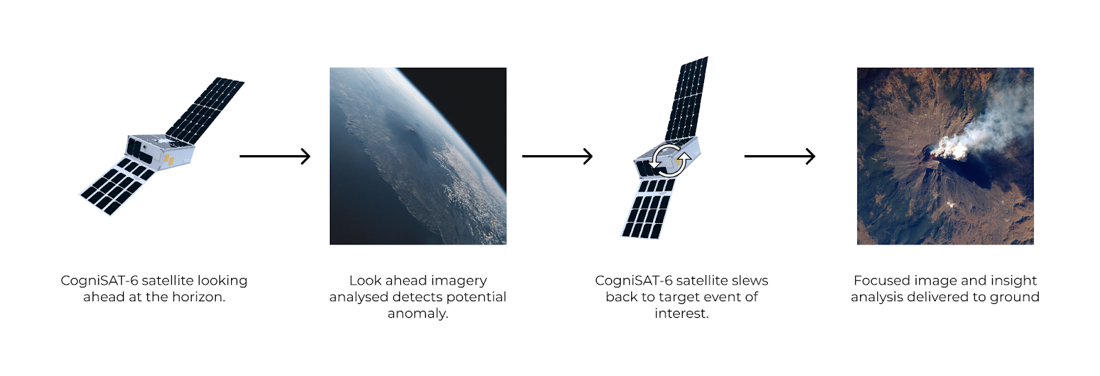
NASA’s Jet Propulsion Laboratory (JPL) has designed and developed a custom AI-driven dynamic targeting application. This runs on CogniSAT-6, which is an Open Cosmos built CubeSat satellite that is co-operated by Ubotica and Open Cosmos. The dynamic targeting application runs on Ubotica’s SPACE:AI Edge processing platform, which incorporates flight software and hardware to support the execution of AI processing of the dynamic acquisitions. Here’s an example of how it works in practice, with approximate timings:
The Technical Process
- Lookahead Imaging (T-90 seconds)
- The CogniSAT-6 satellite orients its imager forward and captures imagery 40-60 degrees ahead in its orbital track
- At 500km altitude, this provides a view of what the satellite will overfly 60-90 seconds in advance
- This lookahead covers approximately 10s to 100s of km² of Earth’s surface
- Rapid Onboard Analysis (T-60 seconds)
- SPACE:AI’s edge computing processes the lookahead imagery in real-time
- JPL models ported to SPACE:AI detect clouds, thermal anomalies, or specific signatures of interest
- The entire analysis completes in under 5 seconds using Ubotica’s CogniSAT hardware and software platform
- Intelligent Decision Making (T-45 seconds)
- Based on the analysis of the detections, the onboard system autonomously decides an optimal targeting strategy:
- Avoid cloudy areas for clear surface imaging
- Target detected thermal anomalies for wildfire or volcano monitoring
- Track rare atmospheric events as they develop
- Commands are generated for satellite reorientation and sensor reconfiguration
- Based on the analysis of the detections, the onboard system autonomously decides an optimal targeting strategy:
- Precision Targeting (T-40 seconds)
- CogniSAT-6 executes the commanded slew reorientation manoeuvres to position for optimal observation
- The satellite prepares for high-value data collection
- Smart Data Collection (T-0 seconds)
- CogniSAT-6 captures targeted imagery of the autonomously identified area of interest
- SPACE:AI immediately processes the data onboard to extract key insights
- Critical insights can be transmitted via inter-satellite links within minutes
World First: Ubotica and NASA JPL Make It Real
Whilst the concept of dynamic targeting has existed in research papers, making it work in the harsh realities of space is another matter entirely. That’s
why our collaboration with NASA’s Jet Propulsion Laboratory is so significant.
In July 2025, NASA JPL and Ubotica, operating on our CogniSAT-6 satellite, demonstrated the world’s first operational deployment of Dynamic Targeting on a CubeSat. This isn’t a laboratory experiment or a simulation—it’s a real flight operation on a commercial satellite already in orbit, processing real data, and making real decisions, in real-time.
The technical challenges we’ve overcome are substantial:
- Meeting the demanding 60-90 second timeline imposed by orbital mechanics
- Achieving the computational performance needed for the rapid onboard decision making using AI
- Integrating lookahead analysis with precision satellite control
- Precision slewing to focus on a key event
- Proving the system works reliably in the space environment
From Imagery to Intelligence
This shift from passive observation to active intelligence transforms Earth Observation at every level:
For Emergency Responders: Instead of waiting hours or days to discover a wildfire, dynamic targeting can detect thermal anomalies at ignition and alert in real-time.
For Maritime Security: Our proven dark vessel detection, enhanced with dynamic targeting, can intelligently scan vast ocean areas, dynamically focusing on suspicious vessels approaching areas of interest or critical infrastructure, rather than blindly imaging empty water.
For Climate Scientists: Rare atmospheric events that traditional satellites capture opportunistically can now be actively hunted and studied, greatly improving our understanding of Earth’s climate system.
For Constellation Operators: Each satellite becomes dramatically more productive, capturing up to 20x more valuable data (based on literature) whilst drastically reducing useless featureless imagery.
Building An Orbital-AI Layer Where Satellites are Intelligent Agents
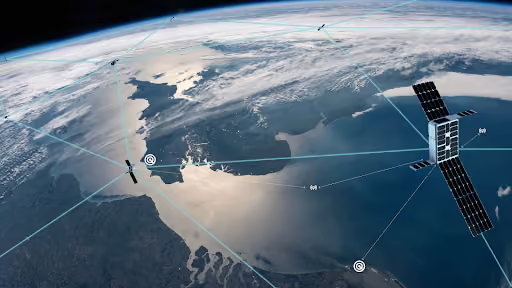
Dynamic targeting represents just the beginning. At Ubotica we’re enabling what we call the “SPACE:AI Layer”—a distributed intelligence network where satellites don’t just carry sensors, they carry understanding.
Imagine satellites that:
- Coordinate observations across a constellation, with one satellite alerting others to developing events
- Learn from each observation, continuously improving their ability to identify what matters
- Respond to dynamic tasking requests and updated mission goals in near real-time
- Work together to maintain persistent intelligence on critical areas
This is Live Earth Intelligence—where the time between an event occurring and humans understanding it shrinks from days to minutes, and where order of magnitude more data of value is acquired versus the traditional ‘mow the lawn’.
This entire sequence—from looking ahead to insight extraction—completes whilst the CogniSAT-6 satellite travels the distance from London to Berlin, all in less time than you’d wait at a red light. Read more details about Dynamic Targeting here:
The Flight of Dynamic Targeting on the CogniSAT-6 Spacecraft
Dynamic Tasking
How NASA Is Testing AI to Make Earth-Observing Satellites Smarter
World First: Ubotica and NASA JPL Make It Real
Whilst the concept of dynamic targeting has existed in research papers, making it work in the harsh realities of space is another matter entirely. That’s
why our collaboration with NASA’s Jet Propulsion Laboratory is so significant.
In July 2025, NASA JPL and Ubotica, operating on our CogniSAT-6 satellite, demonstrated the world’s first operational deployment of Dynamic Targeting on a CubeSat. This isn’t a laboratory experiment or a simulation—it’s a real flight operation on a commercial satellite already in orbit, processing real data, and making real decisions, in real-time.
The technical challenges we’ve overcome are substantial:
- Meeting the demanding 60-90 second timeline imposed by orbital mechanics
- Achieving the computational performance needed for the rapid onboard decision making using AI
- Integrating lookahead analysis with precision satellite control
- Precision slewing to focus on a key event
- Proving the system works reliably in the space environment
From Imagery to Intelligence
This shift from passive observation to active intelligence transforms Earth Observation at every level:
For Emergency Responders: Instead of waiting hours or days to discover a wildfire, dynamic targeting can detect thermal anomalies at ignition and alert in real-time.
For Maritime Security: Our proven dark vessel detection, enhanced with dynamic targeting, can intelligently scan vast ocean areas, dynamically focusing on suspicious vessels approaching areas of interest or critical infrastructure, rather than blindly imaging empty water.
For Climate Scientists: Rare atmospheric events that traditional satellites capture opportunistically can now be actively hunted and studied, greatly improving our understanding of Earth’s climate system.
For Constellation Operators: Each satellite becomes dramatically more productive, capturing up to 20x more valuable data (based on literature) whilst drastically reducing useless featureless imagery.
Building An Orbital-AI Layer Where Satellites are Intelligent Agents
Dynamic targeting represents just the beginning. At Ubotica we’re enabling what we call the “SPACE:AI Layer”—a distributed intelligence network where satellites don’t just carry sensors, they carry understanding.
Imagine satellites that:
- Coordinate observations across a constellation, with one satellite alerting others to developing events
- Learn from each observation, continuously improving their ability to identify what matters
- Respond to dynamic tasking requests and updated mission goals in near real-time
- Work together to maintain persistent intelligence on critical areas
This is Live Earth Intelligence—where the time between an event occurring and humans understanding it shrinks from days to minutes, and where order of magnitude more data of value is acquired versus the traditional ‘mow the lawn’.
The Future is Already in Orbit
As we continue our demonstration with NASA JPL, we’re not just proving a technology—we’re proving a radical new approach. Earth Observation shouldn’t be about collecting vast archives of imagery hoping something useful is buried within. It should be about understanding our planet as it lives and breathes, capturing the moments that matter, and delivering insights when they can still make a difference.
The transformation from passive observation to Live Earth Intelligence isn’t coming—it’s here. CogniSAT-6 is already in orbit, SPACE:AI is already processing data, and in July 2025 we’ve shown the world what happens when satellites stop simply looking and start truly seeing.
For satellite operators, Earth Observation companies, and organisations that depend on timely planetary intelligence, the message is clear: the age of intelligent satellites has arrived.
Welcome to the era of Live Earth Intelligence.
